 |
 |
 |
 |
The Trail of the Gargoyles consists of two separate trails...the North and South Rim Trails...each being about three quarters of a mile. They are easy walks with a few moderate upgrades. It is a good idea to wear hiking boots or sturdy shoes since there are some areas that are slippery because of the loose soil. Because of the loose soil and dangerously steep slopes, please be cautious!
I would also suggest you pick up a brochure describing the various points of interest...available at both the Mi-Wok and the Summit Ranger Stations. The brochure will match the numbered posts along each trail. Unfortunately there are a few posts missing but you can just about visualize where they would be located.
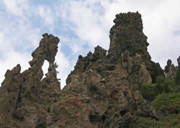
You will be impressed by the wonderful geologic formations left behind from lava flows and glaciers from millions of years ago. (Photos to come.)
Directions: From the Summit Ranger Station located on Highway 108 at the Pinecrest Lake Road exit to Pinecrest, continue east on 108 and turn right onto Herring Creek Road. Continue for about 16 miles until you see the sign on the right side of the road for Trail of the Gargoyles. A little more than half of the road is paved...the rest may be slow going for cars without high clearance.
|
|
|
|
© Copyright 2011 - Images by Adelaide - All Rights Reserved.
|